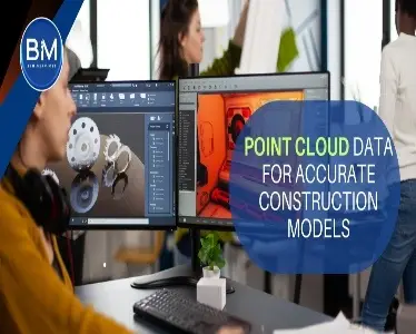
Point cloud data in construction gives you a single, measured source of geometric truth-captured once with 3D laser scanning and carried through your Scan to BIM pipeline. The payoff is simple: as-built models that reflect reality, fewer site revisits, and accurate construction modeling that prefab and field teams can trust. In this guide, we’ll show where point clouds deliver the biggest wins, how to plan and validate a Scan to BIM workflow without bloating your model, and the KPIs that prove it worked-so you can stop guessing and start installing.

What is a Point Cloud Data
A point cloud is a dense set of 3D points-each with X, Y, Z coordinates and often color or intensity-that captures the exact shape and position of real-world surfaces; it’s typically created by 3D laser scanning (LiDAR) or photogrammetry and serves as geometric “ground truth.” In AEC, point cloud data is the starting point for Scan to BIM and as-built models, enabling accurate coordination, clash risk reduction, prefab/installation verification, and deformation or progress monitoring. Quality is described by accuracy and point spacing, and multiple scans are “registered” together and tied to a project coordinate system for consistency. Common formats include LAS/LAZ and E57 (open), plus ecosystem types like RCP/RCS (Autodesk) and POD (Bentley). Limitations to watch for are occlusions, reflective or glass surfaces, sensor noise, and large file sizes-and because a cloud isn’t parametric, you typically model or mesh from it; the workflow is capture → register → clean/segment → model/mesh → validate against the cloud.
What point clouds really give you (beyond “pretty dots”)
Dimensional truth on day one
Scans capture millions of points at real-world coordinates-flatness, plumb, camber, warps, sags-so your accurate construction modeling starts from ground truth, not “as-designed” assumptions.
Cleaner design options, fewer site surprises
Renovations and brownfield work depend on what’s actually there. Point clouds expose hidden offsets, undocumented penetrations, and uneven slabs before you cut steel or pour concrete.
MEPF fit-up that actually fits
When pipe/duct/cable tray routes are modeled against a registered cloud , you avoid the classic “bus duct vs. beam” and “sprinkler vs. ladder” collisions that 2D misses. Tie this to your clash sets and right-of-way checks and your install sequences stick.
Prefab and install confidence
Shop drawings and spools generated from models aligned to clouds go in with fewer field adjustments.
Fast, verifiable progress tracking
Periodic scans let you compare the model to site reality, flag deviations early, and close issues quickly-without arguing over photos.
Stronger handover
You can deliver an as-built that’s not just plausible, but defensible. FM teams get geometry and parameters that match what’s installed.
Where point clouds pay off the most
1. Interiors with dense services (hospitals, labs, data centers, plants)
2. Historic/heritage projects with non-standard geometry
3. Brownfield expansions where every inch of clearance matters
4. Façade/roof packages (true as-built planes, slopes, deflection)
5. Industrial/mechanical rooms (tight layouts, complex penetrations)
Point Cloud Drawbacks
1) Heavy Data & Hardware Load
- Large files strain storage, networks, and GPUs; clip/decimate clouds and work in zones.
2) Line-of-Sight Blind Spots
- Occlusions behind equipment/ceilings leave gaps; plan scan positions and add targeted re-scans.
3) Registration Errors Compound
- Weak control or overlap causes drift; use solid survey control, QA RMS/drift on site.
4) Not Parametric by Default
- Clouds are just points; converting to BIM elements takes time and skill—model only what affects decisions.
5) Material & Environment Limits
- Shiny, dark, transparent, or moving surfaces create noise/holes; adjust scanner settings and add targets.
6) Cost & Access Logistics
- Mobilization, shutdown windows, and specialized crews add cost; focus scans on high-risk areas for ROI.
A practical Scan to BIM workflow that won’t melt your schedule
Plan the capture
Define scope, accuracy tolerance, and coordinate system (shared project base).
Place targets/control; choose density where it matters (penetrations, interfaces).
Capture and register
Scan from overlapping stations; register with constraints (target/targetless); check RMS error and drift before you leave site.
Segment and model
Bring the cloud into your authoring tool; classify regions (structure, MEP, architectural); model to the LOD the downstream team needs-nothing more.
Validate
Run color-map deviation checks; set acceptance bands (e.g., ±10 mm architectural, tighter for equipment pads).
Document exceptions and update the BEP so the rule becomes habit.
Deliver and maintain
Package the model plus read-only cloud segments for future checks.
Re-scan critical areas at milestones to keep the model honest.
Concrete benefits you can defend with KPIs
1. Rework down, especially on MEP hangers, sleeves, and penetrations
2. Fewer site revisits (one capture replaces multiple manual surveys)
3. Install hit rate up for prefabricated racks, skids, and façade panels
4. Clash closure faster (issues are real, not geometry guesses)
5. Handover acceptance smoother (as-built data > arguments)
Tech and file tips that save you pain
Choose formats intentionally: E57/LAS/LAZ for interchange; RCP/RCS for Autodesk ecosystems; keep raw scans archived.
Model only what has consequences: major structure, envelope, equipment, services, and interfaces. Avoid modeling fasteners and small-bore unless critical-keep them as parameters.
Stay coordinate-literate: lock survey control in the BEP; never “eyeball align.”
Document your tolerance bands: publish what “green” vs “red” means on deviation maps so reviews aren’t subjective.
Common pitfalls (and the fix)
Over-modeling the cloud → Model to use-case LOD; store small stuff as properties.
Messy registration → Validate in the field; fix while the tripod is still out.
No CDE discipline → Name scans/models consistently; version and gate reviews.
Treating scans as decoration → Tie scan checks to approval gates and pay apps.
Executive for buy-in
Scan once, decide faster, and install with confidence.
Use clouds to de-risk coordination and prove your as-built.
Keep models light, tolerances explicit, and checks automated.
Start with one pilot area, publish the win, then scale.
Conclusion
Scan once; decide with confidence. Point cloud data in construction turns site conditions into measurable truth so your Scan to BIM pipeline produces as-built models that actually fit. Start small: pick one high-risk zone, lock survey control, define tolerance bands, and run deviation maps at each gate. Track hard KPIs-MEP rework hours, clash cycle time, install hit rate for prefabs, and punchlist density. Keep models lean (model what affects decisions), treat the cloud as read-only ground truth, and standardize delivery so 3D laser scanning becomes a repeatable habit-not a one-off “nice to have.”