Introduction
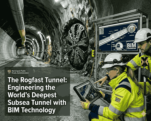
The Rogfast Tunnel in Norway is set to become the world’s deepest and longest subsea road tunnel, descending 392 meters below sea level and stretching approximately 27 kilometers to improve connectivity along the E39 coastal highway. The project demonstrates the critical role of BIM technology in managing complex, large-scale infrastructure, utilizing advanced 3D models and digital coordination to prevent conflicts and ensure safety.
What Makes the Rogfast Tunnel Unique?
A subsea tunnel is an excavation tunnel dug deep under the seafloor joining two land areas. While underwater structures lie directly on the bottom of the sea, subsea tunnels penetrate deep into rocks under the seabed at a depth of hundreds of meters. The Rogfast Tunnel reaches an unparalleled depth of 392 meters below sea level, thus setting all-new records. Such depth presents not only formidable technical challenges but also offers unique opportunities.
For the very first time, due to innovative Building Information Modelling technology, engineers can see, organize, and analyze such tunnels’ design long before they begin building them. Thanks to a 3D model, one can detect possible flaws, adjust the design, and ensure flawless BIM coordination between the structure itself, its ventilation system, electric equipment, and security devices.
Engineering Challenges Beneath the Seabed
Extreme Water Pressure
Pressure at a depth of 392 meters is about 40 atmospheres – forty times greater than the pressure at sea level. Such a tremendous force acts on the tunnel walls all the time. The task of engineers is to design such structures to resist these intense pressures for a design lifespan of 120 years. BIM Technology assists engineers in creating 3D models where they can apply loads of pressure, test their designs, and ensure the tunnel will be safe enough.
Waterproofing and Seepage Control
For waterproofing a tunnel built below the sea level at a depth of 392 meters, multiple layers are necessary. For instance, it is necessary to apply waterproof membranes, chemically-treated grouting materials, and drainage systems. It must be done so that the waterproofing will serve for a very long time. In the three-dimensional models generated using BIM technology, it will be possible to develop the design of waterproofing without conflicting with the tunnel structure.
Structural Reinforcement
The tunnel structure is stabilized using rock bolts and layers of sprayed concrete (shotcrete) combined with extensive bedrock grouting. At very high pressures, even minor millimeter errors can affect the stability of the tunnel excavation. BIM Services assist in this matter by designing accurate 3D Models that clearly dictate the exact positions where each component needs to be placed. The design guides production, and clash detection will detect any inconsistencies in the construction sequence during execution.
Tunnel Excavation Using TBMs
Instead of using Tunnel Boring Machines, crews excavate through the solid rock continuously using advanced drill-and-blast methods. As geological conditions change along the subsea route, engineering teams must rapidly adapt support strategies and grouting approaches. Real-time monitoring and 3D laser scanning feed data directly into digital construction systems after each blast. BIM Technology integrates this live geological information with the structural design, enabling highly adaptive excavation plans. Teams can model different scenarios, predict bedrock challenges, and adjust strategies based on actual site conditions, significantly reducing risks and surprises during construction.
Safety, Ventilation, and Project Coordination
Safety issues in a 27-kilometer tunnel under water arise from the fact that people can’t evacuate the facility as easily as if they were driving on an overground road. Fire detection, fire suppression, proper lighting during evacuation, clearly marked escape routes, and adequate ventilation are some of the necessary facilities that the tunnel should incorporate. Ventilation in particular should introduce new air into the tunnel while removing fumes and smoke in case of fires. Planning for all these systems requires great skills.
The application of BIM Technology makes such planning easier since there are clash detection mechanisms in 3D modeling. These mechanisms automatically detect whether or not the ventilation systems, the escape routes, the electrical system, and structural elements clash. They also confirm that no element obstructs the escape route or reduces the area available for ventilation. It is through BIM Consulting Services that experts specializing in safety coordination become available for checking such designs using 3D models.
How BIM Supports Modern Tunnel Construction
BIM Technology stands for Building Information Modeling. It involves an innovative way of designing complex infrastructure projects. Through this technology, architects, structural engineers, mechanical and electrical specialists, safety coordinators, and construction managers all collaborate within a single, unified 3D model. While previous project frameworks forced different specialists to work on isolated, conflicting drawings, BIM provides a centralized workspace for everyone.
In addition to being a coordinated platform, it offers a highly precise, detailed geometric representation of every component within an infrastructure asset like the Rogfast Tunnel—including its physical shell, ventilation network, power grids, and emergency systems. Clash detection software automatically scans this digital twin to ensure that ventilation ducts do not intersect structural elements, electrical setups do not interfere with routine maintenance, and safety hardware does not obstruct critical emergency escape routes.
Conclusion
The Rogfast Tunnel represents extraordinary engineering achievement. At 392 meters deep and 27 kilometers long, it demonstrates how modern infrastructure projects push technological boundaries. The project’s success depends equally on engineering expertise and BIM Technology. Digital coordination through 3D Models, Clash Detection, and integrated BIM Services enables teams to manage unprecedented complexity, prevent design conflicts, and ensure that safety systems work seamlessly.
Disclaimer
This article is for educational purposes only. References to BIM Technology, 3D Models, Clash Detection, BIM Services, and BIM Consulting Services represent common industry practices and are not confirmed as the specific technologies or Construction workflows used on the Rogfast Tunnel project. Readers should refer to official Rogfast project documentation and engineering sources for verified information about actual project methodologies and technologies employed.
References
For comprehensive engineering video breakdowns, media profiles, and design portfolios regarding the E39 coastal link, you can review the following resources:
- Video Analysis: Watch the detailed documentary on structural mapping and construction challenges at The B1M: Inside the World’s Deepest Subsea Tunnel.
- Media Coverage: Read the complete geographic report on the West Coast corridor transformation at CNN Travel: Norway Longest Deepest Underwater Tunnel.
- Engineering & Design Case Study: Review the exact technical project layout, multi-disciplinary modeling information, and subterranean roundabout specifications directly from the planners at the Norconsult E39 Rogfast Project Portfolio.